Balbharti Maharashtra State Board Class 12 Geography Solutions
Chapter 3 Human Settlements and Land Use Textbook Exercise Questions and Answers.
1. Identify the correct correlation.
A : Assertion R : Reasoning
Question 1.
A – Settlements can be of various types.
R – Various physical factors affect the growth of settlements.
(a) Only A is correct.
(b) Only R is correct.
(c) Both A and R are correct and R is the correct explanation of A.
(d) Both A and R are correct but R is not the correct explanation of A.
Answer:
(d) Both A and R are correct but R is not the correct explanation of A.

Question 2.
A – When cities grow, their functions also grow.
R – Cities can have only one function.
(a) Only A is correct.
(b) Only R is correct.
(c) Both A and R are correct and R is the correct explanation of A.
(d) Both A and R are correct but R is not the correct explanation of A.
Answer:
(a) Only A is correct.
2. Give geographical reasons.
Question 1.
Not all rural settlements change into urban settlements.
Answer:
Question 2.
In rural settlements, land use is related to agriculture.
Answer:
Question 3.
Rural-urban fringe have the characteristics of both urban and rural settlements.
Answer:
Question 4.
Growth of urban areas is linked to land use.
Answer:
3. Write short notes on.
Question 1.
Interrelationship between urban and rural settlement.
Answer:
Question 2.
Problems of urban settlements.
Answer:
Question 3.
Suburbs
Answer:
Question 4.
Mixed land use.
Answer:
4. Answer the following questions in detail.
Question 1.
Explain the characteristics of rural settlement.
Answer:
Question 2.
What factors are responsible for development of various patterns in settlement? Give examples.
Answer:
1. Patterns of settlements are affected by various physical factors like relief, soils, climate, availability of water supply etc.
2. Physical factors influence the type and spacing of settlements, which results into various patterns of settlements.
3. Type of soil and quality of soil are two important factors which affect rural settlements.
4. Fertile plains and valleys have thick, rich and fertile alluvial soil, which supports agriculture, so nucleated settlements develop in these areas. For example, most of the villages in Ganga plains have nucleated settlements.
5. Settlements develop as per the relief of that area. For example, Foothill settlements develop at the foot of mountain, hilltop settlements develop at the top of the hill. For example, hilltop settlement at Shimla or Manali.
6. In the areas of mountainous or hilly relief, due to inaccessibility, there are dispersed or isolated settlements. For example, dispersed or isolated settlements in Himalaya mountains.
7. Sometimes settlements develop along the coastline, canal, river, road, or railway line. They are in straight line; they are called linear settlements. For example, settlements along Konkan coastline and settlements along Mumbai-Pune road.
8. Climate also affects development of settlements. Areas of extreme climate are avoided by people. Therefore, such areas have dispersed settlements.
9. For example, due to extreme hot climate there are dispersed settlements in Rajasthan and due to extreme cold climate, there are isolated settlements in the polar regions.
10. Water is essential for human development. Therefore, many settlements develop around lakes or natural tanks, they are circular settlements.
11. Sometimes settlements develop at the confluence of two rivers, the settlements grow in all three sides, they are triangular settlements. For example, Karad town is on the confluence of Krishna and Koyna river.
12. Sometimes settlements grow around the mines, or any central object. This centre point provides source of livelihood to the people. Thus, radial pattern of settlement develops. For example, radial settlements around coal mines in the State of Bihar.
5. Differentiate between.
Question 1.
Land Use and Land Cover
Answer:
Question 2.
Barren and Non-agricultural Land
Answer:
Question 3.
Radial pattern and Circular Pattern
Answer:
Question 4.
Nucleated and Dispersed Settlement
Answer:
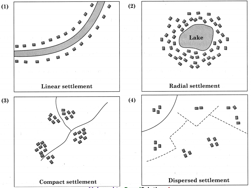
6. Draw a neat and labelled diagram
(1) Linear settlement
(2) Radial settlement
(3) Compact settlement
(4) Dispersed settlement
Answer:
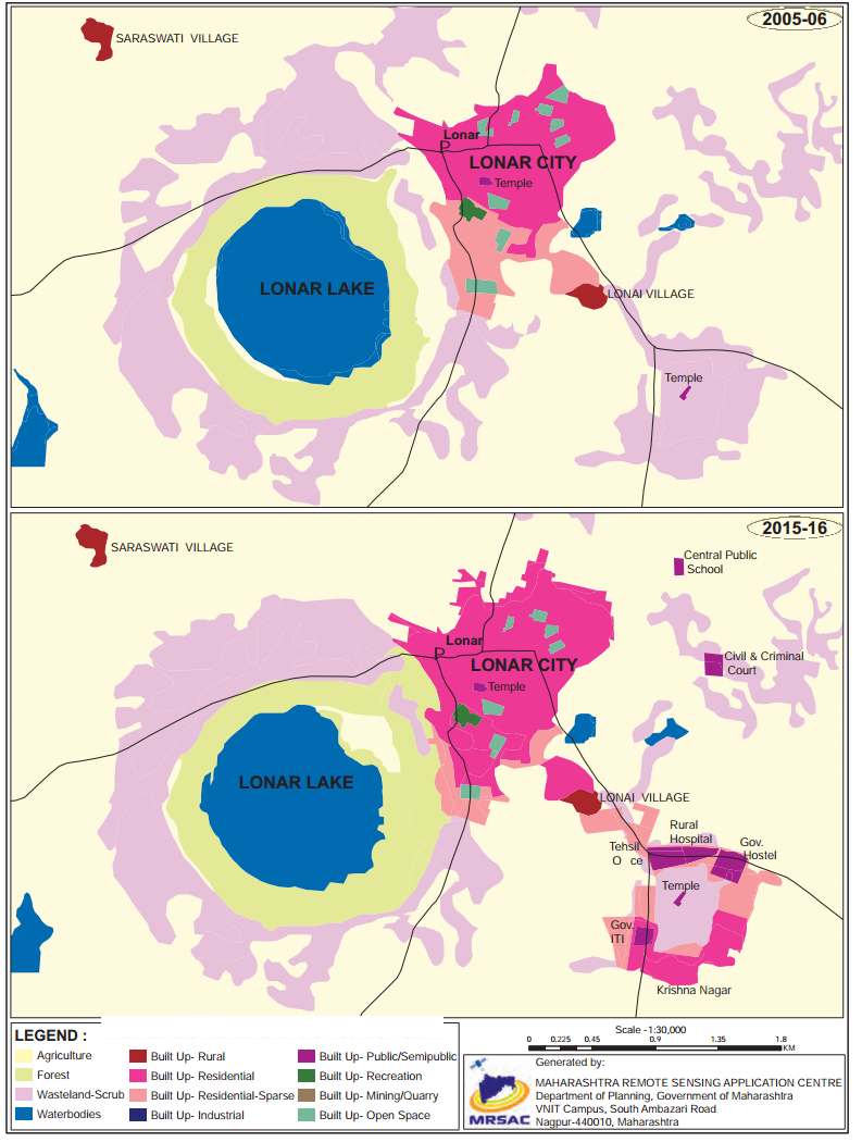
7. Write a note in your own words about how land used in Lonar city has evolved. Refer the map on textbook page no. 30.
Answer:
8. Read the given passage and answer the following questions.
Different types of human settlements include hamlets, villages, small towns, large towns, isolated places, cities and conurbations. In some systems, types of human settlements are broken up into urban, suburban and rural; for example, the U.S. Census Bureau divides settlements into urban or rural categories based on precise definitions. Small settlements, such as hamlets and villages, have low populations and restricted access to services, larger types of settlements, such as cities, have higher populations, higher densities and greater access to services.
For example, a village may have only one or two general stores, while a large metropolis may have many specialized stores and chain stores. These differences are known as low-order service settlements and high-order service settlements. Larger settlements also have a sphere of influence affecting surrounding settlements. Settlements may also be divided by the site chosen, such as sites selected based on resources, trading points, defensive sites, shelter and relationship to water resources. The functions of human settlements also differ, as settlements may be established as ports, market towns and resorts. Types of rural settlements may also be classified by function, such as proximity to farming, fishing and mining. Settlements that focus on one economic activity are called single functional settlements. Human settlements may be permanent or temporary. For example, a refugee camp is a temporary settlement, while a city is a permanent settlement.
Question 1.
Which human settlements are mentioned in the passage above?
Answer:
Hamlets, villages, small towns, large towns, isolated places, cities and conurbations are the types of settlements mentioned in the passage.
Question 2.
On what basis are urban and rural areas classified?
Answer:
Settlement are classified on the basis of the size of population, density, access to higher order and lower order services, site chosen, functions, permanent or temporary etc.
Question 3.
What are the functions carried out in rural settlement?
Answer:
Functions carried out in rural settlements are farming, fishing, mining, one or two general stores, etc.
Question 4.
Explain the difference between low-order services and higher order service settlements.
Answer:
Class 12 Geography Chapter 3 Human Settlements and Land Use Intext Questions and Answers
Try These
Question 1.
Observe Fig 3.2 A to F (Textbook Page No. 22-23). They show various patterns of settlements. Try to understand the difference between them. Carefully read their characteristics in the second column. According to the applicable characteristics, write alphabet of the image settlement in the place provided below characteristics.
Answer:
Question 2.
Can you identify problems faced by your city/town/village in terms of any of the following? (Textbook Page No. 27)
Answer:
Make friends with maps!
Question 1.
See map of Ichalkaranji city (Textbook Page No. 28) and observe how changes have occurred in the city over the years. Answer the questions that follow.
(i) Enlist the colours used for showing land uses in the index.
(ii) What do the blue and black lines show?
(iii) What is the name of the river in the map?
(iv) Name any two villages shown on the map.
(v) Which city is shown on the map?
(vi) Which periods do the map belongs to?
(vii) Which land covers have reduced? What are their colours?
(viii)Which landcovers seen to have increased? what are their colours?
(ix) Which land cover has been replaced by increased landcovers?
(x) Write a conclusive note comparing both the maps.
Answer:
(i)
(ii) Blue lines show rivers and black lines show roads.
(iii) Panchaganaga river
(iv) Jambhali and Haroli villages
(v) Ichalkaranji
(vi) 2007 and 2017
(vii) Open space-dark green colour, forest – light green colour, wasteland – light violet colour residential sparse – light orange
(viii) Following landcovers have increased landcover for residential area – colour pink, Landcover for industrial area colour dark blue
(ix) Following land cover have been replaced by increased landcovers. Residential sparse areas are replaced by residential built up land use, open space is replaced by residential built up area and wastelands are replaced by industries.
(x) Map A shows land use and land cover map of Ichalkaranji city in the year 2007.
Can you tell? (Textbook Page No. 27)
You know what is urban and what is rural. What will you call the area that lies between them?
Answer:
Find out (Textbook Page No. 27)
Compare the cover page of Std. XII text book with Std. XI geography text book. Discuss and write a short paragraph about changes in land use / land cover in your own words.
Answer:
Geography Cover Page (Textbook of standard XI)
Geography Cover Page (Textbook of standard XII)
Let’s recall (Textbook Page No. 24)
Can you differentiate between urban and rural settlements?
Answer:
Think about it (Textbook Page No. 24)
Can a town have only one function? Why do the cities become multi-functional?
Answer:
1. Towns do not have only one function.
2. Some towns have one important and major function. They are known by that function. But they have many other functions also. For example, Shirdi in Maharashtra is known for religious function but it has other functions like tourism, education, commercial etc.
3. Cities become multifunctional as they grow. With increase in population demand for various functions increases. As cities grow in size many changes occur and therefore land use also changes.
4. For example, when any city develops as industrial centre, its main function is industries. But as people start coming to that city for employment opportunities, the city grows. Then other functions like educational institutes, business centres, recreational centres, etc., functions develop to fulfil the needs of increasing population. Thus, cities become multi-functional.
Question 1.
Observe Fig. (Textbook Page No. 21) and answer the following questions.
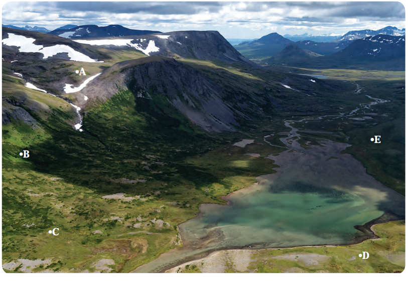
(i) Where are humans’ settlements likely to develop: A, B, C, D or E? Why?
(ii) In the above figure in which place human settlement is not likely to develop? Why?
(iii) Looking at the figure above, what factor do you think could contribute to the development of human settlements?
(iv) Can economic factors be important along with physical factors for the development of human settlements?
(v) Do physical factors affect the economic activity of human settlements?
(vi) Make a list of factors which affect development of settlements in an area.
Answer:
(i) Human settlement is likely to develop at C and D.
The most important factor responsible for the development of settlement is river. Hence, agriculture seems to be the most important activity and development of agriculture needs fertile soil and water supply which is readily available here.
(ii) Human settlement is not likely to develop at A and B. This is because of steep slope and rugged terrain.
(iii) The most important factors that could contribute to the development of human settlements are availability of water from the river and fertile soil on the bank of river.
(iv) Yes, economic factors are equally important along with physical factors for the development of human settlements. For example, industries need development of roads to carry raw material or agriculture also needs development of roads. Many settlements are developed along roads or railway lines.
(v) Yes, physical factors affect the economic activity in the development of human settlement. For example, agriculture is’ an important activity which is affected by relief and water supply. It can be developed where fertile soil and sufficient water supply is available.
(vi) The factors which affect development of settlements are relief, terrain, climate, soil, water supply, altitude, drainage, minerals etc.
Question 2.
Visit http://censusindia.gov.in/2011-prov-results/paper2/data_files/India2/1.%20Data%20 Highlight.pdf to know how cities are divided into various types in India on the basis of their populations. Also look for examples from Maharashtra. Refer to the website and complete the table as given below : (Textbook Page No. 24)
Answer:
Question 3.
On the basis of dominant or specialised functions, Indian cities and towns can be broadly classified as follows. Complete the following table with examples from Maharashtra and India. (Textbook Page No. 24)
Answer:
Chapter 3 Human Settlements and Land Use Textbook Exercise Questions and Answers.
1. Identify the correct correlation.
A : Assertion R : Reasoning
Question 1.
A – Settlements can be of various types.
R – Various physical factors affect the growth of settlements.
(a) Only A is correct.
(b) Only R is correct.
(c) Both A and R are correct and R is the correct explanation of A.
(d) Both A and R are correct but R is not the correct explanation of A.
Answer:
(d) Both A and R are correct but R is not the correct explanation of A.
Question 2.
A – When cities grow, their functions also grow.
R – Cities can have only one function.
(a) Only A is correct.
(b) Only R is correct.
(c) Both A and R are correct and R is the correct explanation of A.
(d) Both A and R are correct but R is not the correct explanation of A.
Answer:
(a) Only A is correct.
2. Give geographical reasons.
Question 1.
Not all rural settlements change into urban settlements.
Answer:
Question 2.
In rural settlements, land use is related to agriculture.
Answer:
Question 3.
Rural-urban fringe have the characteristics of both urban and rural settlements.
Answer:
Question 4.
Growth of urban areas is linked to land use.
Answer:
3. Write short notes on.
Question 1.
Interrelationship between urban and rural settlement.
Answer:
Question 2.
Problems of urban settlements.
Answer:
Question 3.
Suburbs
Answer:
Question 4.
Mixed land use.
Answer:
4. Answer the following questions in detail.
Question 1.
Explain the characteristics of rural settlement.
Answer:
Question 2.
What factors are responsible for development of various patterns in settlement? Give examples.
Answer:
1. Patterns of settlements are affected by various physical factors like relief, soils, climate, availability of water supply etc.
2. Physical factors influence the type and spacing of settlements, which results into various patterns of settlements.
3. Type of soil and quality of soil are two important factors which affect rural settlements.
4. Fertile plains and valleys have thick, rich and fertile alluvial soil, which supports agriculture, so nucleated settlements develop in these areas. For example, most of the villages in Ganga plains have nucleated settlements.
5. Settlements develop as per the relief of that area. For example, Foothill settlements develop at the foot of mountain, hilltop settlements develop at the top of the hill. For example, hilltop settlement at Shimla or Manali.
6. In the areas of mountainous or hilly relief, due to inaccessibility, there are dispersed or isolated settlements. For example, dispersed or isolated settlements in Himalaya mountains.
7. Sometimes settlements develop along the coastline, canal, river, road, or railway line. They are in straight line; they are called linear settlements. For example, settlements along Konkan coastline and settlements along Mumbai-Pune road.
8. Climate also affects development of settlements. Areas of extreme climate are avoided by people. Therefore, such areas have dispersed settlements.
9. For example, due to extreme hot climate there are dispersed settlements in Rajasthan and due to extreme cold climate, there are isolated settlements in the polar regions.
10. Water is essential for human development. Therefore, many settlements develop around lakes or natural tanks, they are circular settlements.
11. Sometimes settlements develop at the confluence of two rivers, the settlements grow in all three sides, they are triangular settlements. For example, Karad town is on the confluence of Krishna and Koyna river.
12. Sometimes settlements grow around the mines, or any central object. This centre point provides source of livelihood to the people. Thus, radial pattern of settlement develops. For example, radial settlements around coal mines in the State of Bihar.
5. Differentiate between.
Question 1.
Land Use and Land Cover
Answer:
| Land Use | Land Cover |
| (i) Land use describes the use of land by people for different activities, such as recreation, housing, agriculture, educational institutes etc. | (i) Land cover describes the physical surface covering the land such as forest rock, ice, sand, water etc. |
| (ii) For example, in any city, people may use some land for housing, some for recreation, some for sports ground etc. | (ii) For example, in any area land may be covered by natural factors such as vegetation, river, sand dune, snow covered mountain etc. |
| (iii) Land use may change from place to place depending upon type of land and need for the people. | (iii) Land cover is natural factor it hardly changes unless man purposefully makes changes in it. |
| (iv) Land use cannot be studied by the satellite imagery alone. | (iv) Land cover can be studied by satellite imagery. |
Barren and Non-agricultural Land
Answer:
| Barren Land | Non-agricultural Land |
| (i) The land which is not used for any human activity is called barren land. In other words, it is wasteland. | (i) The land which is used by man for various human activities except agricultural activity, is called as non-agricultural land. |
| (ii) For example, hilly or mountainous land, desert land, ravines, swampy and marshy land etc. | (ii) For example, land used for housing, industries, construction of roads, railways etc. |
| (iii) Generally barren land cannot be used for agriculture or other activities with available technology. | (iii) Due to the development of secondary or tertiary activities there is increase in the used of non-agricultural land. |
Radial pattern and Circular Pattern
Answer:
| Radial Pattern | Circular Pattern |
| (i) In radial pattern settlements grow around certain object. | (i) In circular pattern settlements grow around water body. |
| (ii) They develop near temple or a centre of commercial activity. | (ii) They develop near lake or natural tank. |
| (iii) For example, settlements near Vindhyachal in Uttar Pradesh. | (iii) For example, settlements around Nainital lake in Uttarakhand. |
Nucleated and Dispersed Settlement
Answer:
| Nucleated Settlement | Dispersed Settlement |
| (i) Settlement where buildings or houses are grouped or clustered around a central point or nucleus is known as nucleated settlements. | (i) Settlement where buildings or houses are scattered or dispersed, is known as dispersed settlement. |
| (ii) Houses or buildings are very close to each other. There may be common wall between two houses. | (ii) Houses or buildings are far from each other. One house may be at a distance of half a kilometre from the other. |
| (iii) Geographical factors are favourable such as spring or fertile river valley. | (iii) Geographical factors are not favourable such as extreme climate, barren land etc. |
| (iv) For example, settlements in river valleys. | (vi) For example, settlements in the desert of Rajasthan. |
(1) Linear settlement
(2) Radial settlement
(3) Compact settlement
(4) Dispersed settlement
Answer:
7. Write a note in your own words about how land used in Lonar city has evolved. Refer the map on textbook page no. 30.
Answer:
8. Read the given passage and answer the following questions.
Different types of human settlements include hamlets, villages, small towns, large towns, isolated places, cities and conurbations. In some systems, types of human settlements are broken up into urban, suburban and rural; for example, the U.S. Census Bureau divides settlements into urban or rural categories based on precise definitions. Small settlements, such as hamlets and villages, have low populations and restricted access to services, larger types of settlements, such as cities, have higher populations, higher densities and greater access to services.
For example, a village may have only one or two general stores, while a large metropolis may have many specialized stores and chain stores. These differences are known as low-order service settlements and high-order service settlements. Larger settlements also have a sphere of influence affecting surrounding settlements. Settlements may also be divided by the site chosen, such as sites selected based on resources, trading points, defensive sites, shelter and relationship to water resources. The functions of human settlements also differ, as settlements may be established as ports, market towns and resorts. Types of rural settlements may also be classified by function, such as proximity to farming, fishing and mining. Settlements that focus on one economic activity are called single functional settlements. Human settlements may be permanent or temporary. For example, a refugee camp is a temporary settlement, while a city is a permanent settlement.
Question 1.
Which human settlements are mentioned in the passage above?
Answer:
Hamlets, villages, small towns, large towns, isolated places, cities and conurbations are the types of settlements mentioned in the passage.
Question 2.
On what basis are urban and rural areas classified?
Answer:
Settlement are classified on the basis of the size of population, density, access to higher order and lower order services, site chosen, functions, permanent or temporary etc.
Question 3.
What are the functions carried out in rural settlement?
Answer:
Functions carried out in rural settlements are farming, fishing, mining, one or two general stores, etc.
Question 4.
Explain the difference between low-order services and higher order service settlements.
Answer:
Class 12 Geography Chapter 3 Human Settlements and Land Use Intext Questions and Answers
Try These
Question 1.
Observe Fig 3.2 A to F (Textbook Page No. 22-23). They show various patterns of settlements. Try to understand the difference between them. Carefully read their characteristics in the second column. According to the applicable characteristics, write alphabet of the image settlement in the place provided below characteristics.
Answer:
| Satellite image of the settlements | Characteristics of settlements |
| Photo A | C |
| Photo B | A |
| Photo C | F |
| Photo D | E |
| Photo E | D |
| Photo F | B |
Can you identify problems faced by your city/town/village in terms of any of the following? (Textbook Page No. 27)
| Types of problems | Problems / Issues |
| 1. Economic | |
| 2. Social | |
| 3. Cultural | |
| 4. Environmental | |
| 5. Infrastructural | |
| 6. Governance and Administrative | |
| 7. Others |
| Types of problems | Problems / Issues |
| 1. Economic | Unemployment and poverty |
| 2. Social | Religious conflicts and tension in society |
| 3. Cultural | Commercialisation of festivals |
| 4. Environmental | Air, water and noise pollution |
| 5. Infrastructural | Inadequate roads, bridges and public transport |
| 6. Governance and Administrative | Increase in crime rate and bribery |
| 7. Others | Overcrowding, traffic jam, housing problem |
Make friends with maps!
Question 1.
See map of Ichalkaranji city (Textbook Page No. 28) and observe how changes have occurred in the city over the years. Answer the questions that follow.
(i) Enlist the colours used for showing land uses in the index.
(ii) What do the blue and black lines show?
(iii) What is the name of the river in the map?
(iv) Name any two villages shown on the map.
(v) Which city is shown on the map?
(vi) Which periods do the map belongs to?
(vii) Which land covers have reduced? What are their colours?
(viii)Which landcovers seen to have increased? what are their colours?
(ix) Which land cover has been replaced by increased landcovers?
(x) Write a conclusive note comparing both the maps.
Answer:
(i)
(ii) Blue lines show rivers and black lines show roads.
(iii) Panchaganaga river
(iv) Jambhali and Haroli villages
(v) Ichalkaranji
(vi) 2007 and 2017
(vii) Open space-dark green colour, forest – light green colour, wasteland – light violet colour residential sparse – light orange
(viii) Following landcovers have increased landcover for residential area – colour pink, Landcover for industrial area colour dark blue
(ix) Following land cover have been replaced by increased landcovers. Residential sparse areas are replaced by residential built up land use, open space is replaced by residential built up area and wastelands are replaced by industries.
(x) Map A shows land use and land cover map of Ichalkaranji city in the year 2007.
Can you tell? (Textbook Page No. 27)
You know what is urban and what is rural. What will you call the area that lies between them?
Answer:
Find out (Textbook Page No. 27)
Compare the cover page of Std. XII text book with Std. XI geography text book. Discuss and write a short paragraph about changes in land use / land cover in your own words.
Answer:
Geography Cover Page (Textbook of standard XI)
Geography Cover Page (Textbook of standard XII)
Let’s recall (Textbook Page No. 24)
Can you differentiate between urban and rural settlements?
Answer:
Think about it (Textbook Page No. 24)
Can a town have only one function? Why do the cities become multi-functional?
Answer:
1. Towns do not have only one function.
2. Some towns have one important and major function. They are known by that function. But they have many other functions also. For example, Shirdi in Maharashtra is known for religious function but it has other functions like tourism, education, commercial etc.
3. Cities become multifunctional as they grow. With increase in population demand for various functions increases. As cities grow in size many changes occur and therefore land use also changes.
4. For example, when any city develops as industrial centre, its main function is industries. But as people start coming to that city for employment opportunities, the city grows. Then other functions like educational institutes, business centres, recreational centres, etc., functions develop to fulfil the needs of increasing population. Thus, cities become multi-functional.
Question 1.
Observe Fig. (Textbook Page No. 21) and answer the following questions.
(i) Where are humans’ settlements likely to develop: A, B, C, D or E? Why?
(ii) In the above figure in which place human settlement is not likely to develop? Why?
(iii) Looking at the figure above, what factor do you think could contribute to the development of human settlements?
(iv) Can economic factors be important along with physical factors for the development of human settlements?
(v) Do physical factors affect the economic activity of human settlements?
(vi) Make a list of factors which affect development of settlements in an area.
Answer:
(i) Human settlement is likely to develop at C and D.
The most important factor responsible for the development of settlement is river. Hence, agriculture seems to be the most important activity and development of agriculture needs fertile soil and water supply which is readily available here.
(ii) Human settlement is not likely to develop at A and B. This is because of steep slope and rugged terrain.
(iii) The most important factors that could contribute to the development of human settlements are availability of water from the river and fertile soil on the bank of river.
(iv) Yes, economic factors are equally important along with physical factors for the development of human settlements. For example, industries need development of roads to carry raw material or agriculture also needs development of roads. Many settlements are developed along roads or railway lines.
(v) Yes, physical factors affect the economic activity in the development of human settlement. For example, agriculture is’ an important activity which is affected by relief and water supply. It can be developed where fertile soil and sufficient water supply is available.
(vi) The factors which affect development of settlements are relief, terrain, climate, soil, water supply, altitude, drainage, minerals etc.
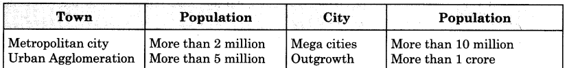
Question 2.
Visit http://censusindia.gov.in/2011-prov-results/paper2/data_files/India2/1.%20Data%20 Highlight.pdf to know how cities are divided into various types in India on the basis of their populations. Also look for examples from Maharashtra. Refer to the website and complete the table as given below : (Textbook Page No. 24)
Answer:
| Classification | Population |
| Class I | 100,00 and above |
| Class II | 50,000 to 99,999 |
| Class III | 20,000 to 49,999 |
| Class IV | 10,000 to 19,999 |
| Class V | 5,000 to 9,999 |
| Class VI | Less than 5000 |
Question 3.
On the basis of dominant or specialised functions, Indian cities and towns can be broadly classified as follows. Complete the following table with examples from Maharashtra and India. (Textbook Page No. 24)
Answer:
| Function | Name of city in Maharashtra | Name of cities outside Maharashtra |
| Administrative | Nashik | Gandhinagar |
| Industrial | Chinchwad | Jamshedpur |
| Transport | Nagpur | Bengaluru |
| Commercial | Mumbai | Surat |
| Mining | Chandrapur | Balaghat |
| Cantonment | Khadki | Agra |
| Educational | Pune | Kota |
| Religious | Pandarpur | Varanasi |
| Tourism | Matheran | Ooty |